If You Always Wanted to Know Where Minetta Brook Flows Through Washington Square Park (and the Village) …
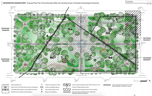
Parks Department Areas of Archaeological Sensitivity Washington Sq Park 2005
Follow line #8 on the above map to see where Minetta Creek flows (once flowed?) under Washington Square. Then check out the YouTube video below which shows the gushing waters viewed through a park manhole. Recent reports suggest that Minetta at the park has gone dry.
This map comes from an Archaeological Assessment of Washington Square Park prepared by the New York City Parks Department in 2005 prior to the park’s controversial redesign. (Does the redesign seem so long ago only to me? Although it’s not quite done even yet – technically the long-awaited sidewalk completion is the last phase.)
The document has been on my computer for years but it wasn’t until I read this post at Local Ecologist that I noted how amazing it is! Some nicely detailed history here (it is worth reading thoughtfully line by line):
In 1808, the upland areas were leveled and the soil was used to fill in the swamp in order to create a burial ground. This intervention affected the eastern two-thirds of the park. (The western one-third of the current park was acquired between 1825 and 1828.) A drain was installed in 1819 to divert Minetta to the south of the burial ground. In 1823 and 1824, Minetta was deepened and culverted in a wooden sewer. The wooden culvert routed Minetta from the eastern section of the site to west of the burial ground.
By 1828, Minetta is completely culverted from the park to the Hudson River. In that same year, the burial ground becomes a park and is officially named Washington Square. A storm and sanitary sewer was transversely laid through the park sometime between 1880 and 1892. After the park’s official founding, trees were planted in 1908 (81 young trees), 1911 (50 trees), 1913 (43 trees), and between 1934-1936. There was a major redesign of the park between 1934 and 1938 and again in the 1990s and 2000s.
Images and content sourced from Washington Square Park Phase 1A Archaeological Assessment by Joan H. Geismar, PhD, LLC through Thomas Balsley Associates for NYC Parks.
—
Steve Duncan has been organizing tours of where Minetta Brook flows in Greenwich Village for years, opening up manhole covers – with a screwdriver – along the way! At the time of this video, he revealed the water gushing underneath Washington Square Park.
Minetta Street follows path of Minetta Creek
Ephemeral New York in 2008 covered Minetta (photo above from the site) noting:
As development pushed northward the brook was diverted beneath Washington Square, where it gurgled its way under the West Village. Minetta Street (below), a tiny lane intersecting little Minetta Place, bends slightly the way its namesake brook supposedly wound across the land.
In the lobby of the apartment building at 2 Fifth Avenue is a clear tube through which Minetta brook used to bubble up out of the ground. Unfortunately, the doorman told me he hasn’t seen any water in it in six years. Could the Minetta have run dry?